by Hugh Semple for Guynode.com
I recently came across the website of the Canada-Guyana Partnership for Community Planning project, which was executed between 2009-2012. Although the project has long ended, I think municipalities and Neighborhood Democratic Councils (NDCs) in Guyana should adopt some elements of this project as a model for incorporating village or community level concerns into broader NDC or municipality development plans.
Project Elements
The stated aim of the Canada-Guyana Partnership for Community Planning project was to support participative planning at the community level in Guyana. This was to be accomplished by bringing together local populations, community leaders, NGOs, business leaders, and government agencies together to work on two things: (1) identifying community development needs, setting goals, and (2) outlining community development plans.
The project targeted 14 communities. For each community, two main tasks had to be completed. The first was to develop a GIS-based community information system to provide stakeholders with detailed and accurate information about their communities.
Secondly, stakeholders were required to identify community development priorities and then document these priorities to create community development plans. Stakeholders also had to identify specific projects that could help achieve the plan’s stated priorities. The specific steps to develop a community plan involved the following steps:
- Engage the community (identifying community groups and leaders)
- Develop a community profile and GIS-based information System
- Define a community vision
- Engage key government stakeholders to find out what govt projects are earmarked for the community and request govt officers to make presentation about these projects
- Establish issue-based working groups to identify priorities
- Write the plan, collect feedback and secure approval of the plan
- Develop projects to achieve priorities
The coordinating body for the project was the Central Housing and Planning Authority (CH&PA), which is the central government agency responsible for nationwide planning.
Project Lessons
Looking at the project’s website, my major disappointment was that the community development plans that were developed when the project was in existence were not available for communities around the country to view. In fact, current residents of the very pilot communities are unable to view the plans. The website indicated that the plans were lodged at the Central Housing and Planning Authority. Most likely they are locked away in a cabinet gathering dust.
The baseline data that were collected to inform the plans are also not available for viewing. In my opinion, it would be great if both the baseline data and plans are located and posted to the web for easy access by current residents, and other interested persons.
I will also posit that operating under the CH&PA and not local NDCs is perhaps the main reason why these community development initiatives ended when the project ended. The CH&PA is a national development control agency, and hardly has time for such local development initiatives.
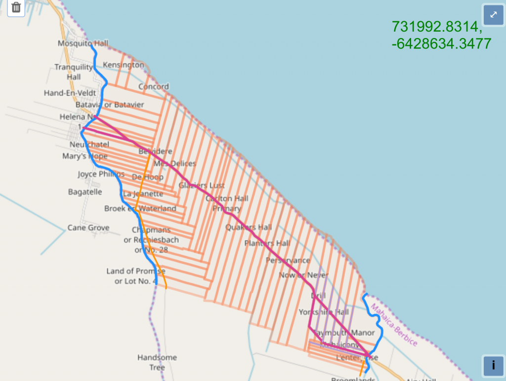
One of the main reasons why I like the work done by the Canada-Guyana Partnership for Community Planning project is that it provides a model that can possibly reduce emerging dissatisfaction of the role of villages within NDCs. Guyana has hundreds of villages along the coast and these have now been aggregated into 60 or more coastal NDCs for local government administration. Click here for village and NDC maps.
Since village identities go back to the plantation era of the 1800s, they are well entrenched in the memory and culture of the coastal population. Historically, villages were managed by their own councils. However under the current local government system, they are subsumed into Neighborhood Democratic Councils. Many people feel that NDCs have wrested the right of villages to be local autonomous units planning for their own development. So, calls for greater village autonomy are becoming increasingly strident, particularly in some predominantly Afro-Guyanese villages.1
I believe NDCs do play an important organizing role in Guyana’s local government system because the sheer number of villages make the system cumbersome and difficult to manage. In addition, some villages have very small populations and would do better as part of a neighborhood democratic council rather than functioning as autonomous local government units.
I think that within the current NDC system, there is functional space for villages to chart and manage their own affairs. This can be accomplished by giving villages the responsibility of coming up with their own development plans and associated projects, and allowing them to implement village-level projects with the help of NDCs.
Conclusion
The community plans that were developed under the Canada-Guyana Partnership for Community Planning project were not explicitly developed to address village level/NDC antagonisms. However, the planning process utilized by that project illustrates how communities can be organized to conduct their own physical planning.
To build on this project, municipalities and NDCs should replace the Central Housing and Planning Authority as the project facilitator and encourage the individual villages and districts within their jurisdiction to develop plans that reflect their local priorities. These plans could then form one of two major components of NDC development plans. The other component would be NDC-wide development projects that can benefit all villages or districts within a NDC.