Re-conceptualizing the Role of Villages within Guyana’s Local Govt System

by Hugh Semple

Between 2015 and 2018, Guyana held two local government elections. This was an impressive feat for a country which had only held village-level local government elections twice during the previous 45 years. Both the Afro-dominated PNC and the Indo-dominated PPP administrations regard local government elections as significant barometers of their political performance and refuse to allow such evaluations.  As a result, local government itself is a very institution weak within the political structure of Guyana. In short, the current generation of Guyanese have very limited experience with local government.

The APNU/AFC coalition assumed power in 2015 with a renewed commitment to improve local government. The holding of local government elections twice between 2015 and 2018 is a reflection of their commitment to promoting this level of government. The coalition also conferred township status on three communities within the same period of time.

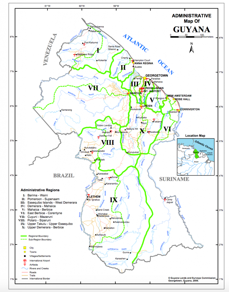
As is widely known, Guyana is sub-divided into ten administrative regions called Regional Democratic Councils (RDCs) (Figure 1).  These Councils are responsible for implementing a significant proportion of the social and infrastructure budgets of Ministries within their council areas. They are typically engaged in repairing major roads and canals, maintaining or building new sea defenses, schools, health care facilities, etc. They also actively participate in the management of health, education, and police services within their jurisdictions.

Figure 1. Administrative Region of Guyana

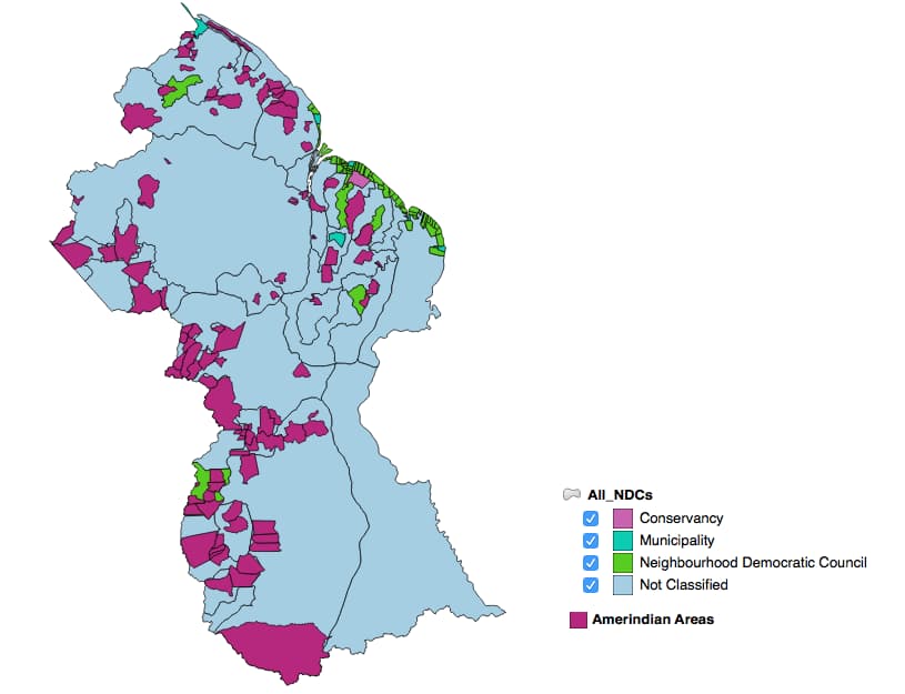
Each Regional Democratic Councils is subdivided into Municipalities, Neighborhood Democratic Councils, and Amerindian Villages (Figure 2).  Municipalities are urban communities with city or town status. Thus, Georgetown, New Amsterdam, Linden, Rose Hall, Bartica, etc are all municipalities.   Neighborhood Democratic Councils (NDCs) are essentially groups of nearby villages. The vast majority of NDCs are located on the narrow coastal plain where more than 90% of the country’s population resides.  Amerindian villages are local government areas within the interior of the country. A large part of the country is neither NDCs nor Amerindian villages due to lack of population. 

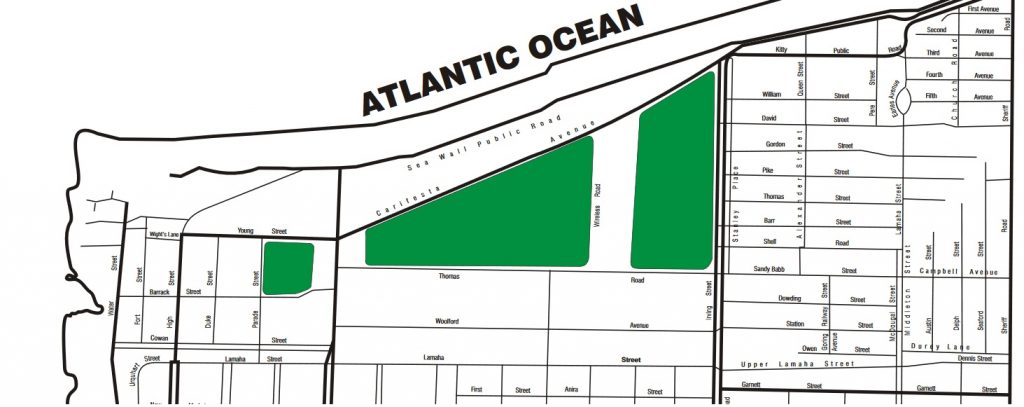
Figure 2. NDCs and Amerindian Villages, Guyana

NDCs and Amerindian village elections are required every three years, while elections for Regional Democratic Councils are required every five years at the time of the national elections.   While elections for regional administrative councils have been held consistently, the same is not true for elections for NDCs and Amerindian villages. As mentioned earlier, for political expediency, Guyana does not have a strong tradition of holding these elections. 

Villages

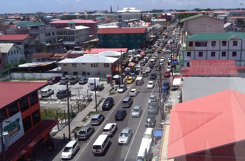
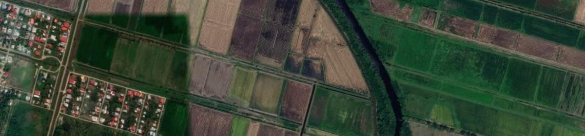
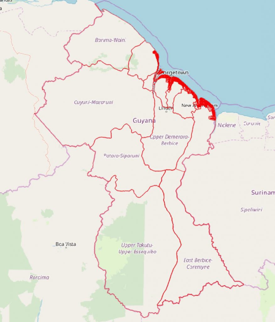
A cursory look at a map of Guyana shows that the coastal area, where most of the country’s population reside, is sub-divided into hundreds of tiny villages with average width of one-quarter of a mile and average length of 6 miles.  These villages were the original coffee, cotton, and sugar plantations established by Dutch settlers in the 18th and 19th centuries.  Historically, the plantations served as areas for both agriculture and residences and have evolved into the basic geographic unit of ‘village’ along the coast. 

Outside of the home and immediate neighborhood, Guyanese who live in non-urban areas identify with the ‘village’.  Family lands, either individually owned or “children property” are tied to the village, as do childhood memories of play, school, or any number of livelihood activities.  Even among Guyanese who live overseas in London, New York, Toronto, or any number of places, an encounter with someone from their village is occasion of special fondness. 

Figure 3. Villages on Guyana’s Coast

Given this strong sense of village attachment and identity, it is curious that current local government restructuring in Guyana has not sought to tap into these sentiments to help organize and manage people for local economic development. Indeed, until the 1970s, local government was organized around the village. Each village had a local council whose responsibility was to manage the various canals, sluices (kokers), and dams on which the village depended to survive the main environmental threat of flooding.  Given the geography of Guyana’s coastal plain, these environmental constants have not changed.  The land is still subjected to flooding from waters draining from the backlands, and because its average elevation is approximately six feet below high tide, flooding from the sea is still a constant worry.

Over the years, village-based local government had been abandoned because these units were deemed too small for effective environmental and socio-economic management. A fundamental argument was that these units resulted in too many unnecessary duplication of functions leading to higher administration costs and inability to reap economies of scale.  

The first attempt at replacing village councils with larger units was made by President Forbes Burnham under Guyana’s new constitution in 1980. It called for a six-tier system with Regional Democratic Councils at the top of the system and five other types of local democratic councils below, excluding village councils (Regional Councils, sub-Regional Councils, District Councils, Community Councils, Neighborhood Councils, and People’s Cooperative Units,).   Due to the top-heavy nature of this system, it was replaced by the current system in 2007, which only has two tiers. i.e, the Regional Democratic Councils at the top level and municipalities, NDCs, and Amerindian villages at the second level.

The Identity Problem of NDCS

A cursory examination of the boundaries of NDCs shows that they are combinations of nearby villages and their boundaries always follow the boundary of some village.

While NDCs appear to be reasonably-sized geographic units, it appears that one of their main issue is that people have weak emotional attachment to these units.  Indeed, people seem to be aware that their village is part of an NDC, but they lack intuitive knowledge of the geographic extent of their NDC and how the NDCs are organized politically and administratively.  The challenge facing local government officials is how best to integrate the strong coordinating role of NDCs with the historical and emotional attachments Guyanese have towards their villages.

One reason for strengthening the role of villages within NDCs is that it will negate recent calls by some political operatives to dispense with NDCs on the grounds that they are impersonal and insensitive to property rights and other development needs within individual villages1,2 .  In the words of one Afro Guyanese leader, people have “lost control over their villages and more particularly over their lands and the lands are now subject to decisions by bodies called Neighbourhood Democratic Councils, many of which are alien to the people whose fore-parents purchased those lands and the people who still reside in those villages”.

It is further argued that Afro villages frequently find themselves located in NDCs dominated by people of Indian descent, who make land-use decisions that are contrary to the needs of the few Afro dominated villages within the NDCs. The reverse of this argument is also true. In a country dominated by race-based politics and administrative decisions, these arguments find resonance among many people. Clearly, additional attention should be given to the role of villages within NDCs

Better Integrating Villages into NDCs

One possible way of strengthening the role of villages within the current local government structure is to assign them the responsibility of administering a set of services that can be easily handled by these small groupings of people. Such services could include approval of land use and building applications, garbage collection, weeding of roads and canals, maintenance of playgrounds and burial grounds, etc.  Currently, these functions are assigned to NDCs. In instances where villages are unable to perform these services, or do not want the responsibilities, then the NDC can continue to provide them. 

To better differentiate between NDC and village functions, I advocate that NDCs be responsible for providing services that can be efficiently provided at the multi-village level. Such services could include maintenance of major dams, drains and canals, potable water supply, local climate change planning, and local economic development.

References

Denis Chabrol , May 2019.  Afro-Guyanese pushing for return to village councils because NDCs have taken control.


Towards Making Georgetown, Guyana a Top-Class Caribbean City

With an oil impending boom, it is hard for urban planners not to speculate as to what Georgetown can become if its citizens and municipal government have the will to transform their beloved capital city. Here I share some thoughts that might be useful in the beginning stages of this city’s transformation.

Comprehensive Plans

My first suggestion is that City Hall develop a comprehensive plan that contains a 20-year vision for the city. The plan should be lofty, bold, motivating, and inclusive.   It should contain proposals for modernizing all the major subsystems of the city including local economy, housing, transportation, shopping, recreation, drainage, etc.  I suggest that the city hire a reputable planning company with considerable experience to conduct surveys to find out the kind of city in which people really want to live, work and play over the next 20 year. The comprehensive plan must be a combination of people’s aspirations plus cutting-edge urban design ideas.

While my primary focus here is on Georgetown, similar plans should be realized for other major urban places in Guyana including Linden, New Amsterdam, Rose Hall, Corriverton, Bartica, Parika.

Also, now might be a good time for urban and regional planners to start thinking about the possible relocation of Guyana’s capital given the realities of climate change.

Clean up Georgetown

While we await formal surveys and comprehensive planning documents addressing visions and goals for the major sub-subsystems of Georgetown, there are plenty low-cost initiatives that can be done to help Georgetown step into its new role on the world scene.  For starter, initiating a ‘keep-the-city-clean’ campaign is something that should be done immediately. After all, Georgetown is becoming an important international destination for many business people and a clean city is good for local economics, regardless of the level of development of the city. 

Cleaning up Georgetown and keeping it clean on a daily basis is not a Herculean task. At the beginning of the Granger’s regime, Georgetowners were motivated to clean up their city. Within a short time, many canals, drains, alleys, intersections, and public places in the city were cleared of trash and people felt better as the city took on a new appearance. 

Here, I am talking about consistently maintaining clean living spaces. Indeed, an industry with hundreds of jobs can be created around this activity.  I advocate that garbage containers be placed everywhere in the city’s downtown and other public spaces. The city’s public health department should use TV, radio, newspapers and other means to encourage people to maintain clean living and working spaces. I also suggest that scores of workers be hired to just pick up and dispose of roadside litter.

Trash Bins

As Georgetown is located in the tropics, the constant heat and moisture give rise to much plant growth. This should be an opportunity for thriving landscaping businesses.  Parapets should be constantly weeded, and drains cleaned. In particular, the lawns in public places should be regularly trimmed and large canals need to be kept clean. And the Le Repentir Cemetery should be transformed into a burial park where visiting the final resting places of loved ones is no longer a challenging task.  

Improve Traffic Circulation

On the matter of traffic circulation, city planners need to begin working on improving vehicular and pedestrian traffic flows within the city’s downtown, especially around the Stabroek Market area. Some amount of planning has been done to that area over the past few years, but because of its centrality to downtown Georgetown, more improvements are needed.

And while we are at this, can city officials just purchase some paint to clearly demarcate road lanes within the city? What’s so hard about that? The pic below shows Regent Street, a busy commercial thoroughfare, with no median line clearly demarcated. Clearly demarcated lanes go a long way in making driving easier and safer.

Regent Street, Georgetown

Parking stall also need to be clearly demarcated. In the picture above, parallel parking is allowed on both sides of the road, but the parking stalls are not demarcated. This should be fixed so to reduce the possibility of conflicts over where motorists should park.

Parking is also still free in Georgetown. A well publicized attempt to install parking meters a few years ago was protested because it was deemed exploitative. However, as more people visit and live in the city, the demand for parking stalls will increase. Therefore, the city needs to revisit the parking issues of the city and come up with modern, workable parking solutions.  

Address the Visual Image of Georgetown

There is also a clear need to address the poor visual image of Georgetown as one approaches from the East Bank. Currently, the view of the city entering from this direction is depressing, mostly because many of the buildings are dilapidated, including La Penitence Market. We need more impressive vistas as one enters the city from the East Bank.  After all, those are the views that foreigners experience on their arrival to the city. I expect that demand for riverfront properties to service the oil industry will cause many of the old buildings to be torn down, but a great deal of cityscape planning is needed in this area.


Party Politics

It is also imperative that Georgetown no longer suffer financial and physical neglect as a result of PPP/APNU conflict, as it did in the past. Georgetown has traditionally voted APNU and, consequently, has not received strong financial support when the PPP is in power. Guyanese politics must mature and acknowledge that regardless of the political party that runs the country, Georgetown must receive adequate financial support from the central government for its physical growth and development. This is not a matter of political patronage; it is a matter of good economics.  Increasingly, Guyana is moving towards a service-based economy, so the livelihood of thousands of people, both within Georgetown and outside of Georgetown, depend on the city being maintained as an attractive and efficient urban center providing services to local and international clients.     

Conclusion

My main point in this post is that City Hall should start visibly working to improve Georgetown so that the city can better adapt to its new role in the global economy.  The city’s government needs to set the tone for its residents.  Together, they can start working to improve Georgetown.

Lack of Street Centerlines Hinders GIS Usage in Guyana

by Hugh Semple

The Street Centerline File

A street centerline is a digital map layer that contains single lines that represent the center of paved and unpaved roads, ramps, bridges, etc. The map is digitized so that nodes are created at each street intersection to capture the topology of the road network. Also, each road segment contains attributes such as street name, street type, address ranges, one-way designations, speed limit, etc. Click on this link for an example of a street centerline file. The file is for the City of Cambridge, Massachusetts, USA.

The importance of the street centerline file is that the topological structure of the dataset allows network analysis including routing analysis to be performed. At the same time, the address ranges in the attribute table allow us to quickly geocode addresses within the street network. GPS devices within vehicles depend on street centerline files for finding addresses and for calculating best routes to destinations. Businesses and public sector agencies use this dataset within their own customized software to look up addresses of customers or clients. Researchers use street centerlines within GIS software to geocode disease and crime events. Of course, without a street centerline dataset, you can’t use Google Map to look up the address of anyone.

Digital Street Maps in Guyana

To be clear, Guyana does have digital street maps. For example, the tourism street map below for Georgetown is a digital street. However, this map is in pdf format and cannot be used by GIS software for geocoding or routing.

Guyana Street Centerlines
Street Map of Georgetown

Partially completed street centerlines for urban areas and NDCs in Guyana can be downloaded from Open Street Map. GuyNode has made such downloads available for Georgetown and Linden on its website. These layers have street names, but the crucial address ranges are missing. Although, one can use these files in GIS software to look up street names, it is not possible to use them to precisely geocode addresses as points. Attributing Guyana’s street maps with address range data is required at this stage. This process can be time consuming and tedious, but since we are dealing with a relatively small country, this task can be executed within a few weeks depending on the number of people involved in the project.

Perhaps the Guyana Lands and Surveys Department could coordinate a street centerline project for the entire country. Or, each municipality and NDC could take on such a project for their particular jurisdiction. Maybe the NDC, municipalities and the Lands and Surveys Department working together could develop this critical map layer. Or, maybe a private GIS company can be given the contract. Regardless of the model adopted, Guyana urgently needs a street centerline file for those parts of the country that have streets and some form of house addressing.

Missed Opportunities

I recently read an article that described several researchers trying to map road accidents in Guyana. It took the researchers a long time to map the data because the accident addresses could not be geocoded. Instead, the coordinates of accident addresses had to looked up on Google Map and then entered into the accident dataset to facilitate mapping. Needless to say, this is an inefficient way of mapping events. Currently, patient addresses from hospital databases cannot be quickly geocoded with this method, so we cannot quickly map and study disease patterns. This is a real pain if there are disease outbreaks.

Crime mapping in Guyana is also severely hindered by the lack of street centerlines. Without such a map layer, the Police Force cannot regularly conduct crime mapping to identify and target shifting crime hot spots in Georgetown and elsewhere.

As the oil industry gathers steam in Guyana, lots of foreigners will be visiting Guyana. Without a good street centerline file, they won’t be able to use the GPS in rented cars. Time to put an end to this situation. I hope that govt can allocate money for this venture in next year’s budget.